![]()
Fuzzy Boundaries
Fuzzy Boundaries on Seneca @ York News
September 8, 2009 - 2:40pm — vicFuzzy Boundaries, the local neighbourhood naming initiative, was recently featured in a video news piece by Chantal Saxe with S@Y News:
You can also view it directly on Youtube here.
The next Fuzzy Boundaries meeting is on Tuesday, September 15 at 7 p.m. at St. Josaphat's Ukrainian Catholic Church (110 Franklin Avenue).
Fuzzy Boundaries in the news
August 29, 2009 - 9:37am — vicThe Fuzzy Boundaries neighbourhood naming initiative was featured by two media outlets yesterday.
Derek, of the popular Toronto website BlogTO wrote A Nameless Neighbourhood Needs Help!. The article discusses the background of the naming project, some of the names that have been used (though curiously it doesn't mention Junction Triangle), and gives the project an overall positive review. The comments after the article are quite lively too.
Later in the evening, the National Post website featured an article by Emily Senger, Between Roncesvalles and Landsdowne, a neighbourhood in search of a name, which I expect will be in today's print edition as well. The article briefly covers some neighbourhood history, as well as other naming efforts from around the city.
Fuzzy Boundaries meeting (Sept. 15)
August 26, 2009 - 11:06pm — vicThe following meeting notice comes from the Fuzzy Boundaries group:
 This image features the many faces of our community past and present.
Who?
While those in the pictures may know each other by name, many aren't sure what to call the neighbourhood.
A residents' group called Fuzzy Boundaries has initiated a naming process for the area. You are invited to our second lively discussion about neighbourhood identities on Tuesday, September 15 at 7 p.m. at St. Josaphat's Ukrainian Catholic Church (110 Franklin Avenue). Urban affairs specialist, CBC broadcaster and National Director of the annual Jane Jacobs Walk, Jane Farrow will discuss the naming experience of the West Queen West community group Active 18. Fuzzy Boundaries member Chris Kwaczek will also speak about neighbourhood demographics.
A Q & A will follow. All are welcome to attend this free event.
For details call Kevin at 416-537-1128 or visit fuzzyboundaries.ca where discussions about our great neighbourhood take place online.
fuzzyboundaries.ca
Colour photo by Vic Gedris, black & white photo City of Toronto Archives, Fonds 200, Subseries 52, Item 665
Fuzzy Boundaries meeting flyer, 2009-09-15
August 26, 2009 - 10:53pm — vic
Flyer for the 2009-09-15 Fuzzy Boundaries meeting.
Fuzzy Boundaries - Neighbourhood naming and identity
April 24, 2009 - 1:16pm — vicThe following meeting announcement comes from the local "Fuzzy Boundaries" group who are working to initiate a neighbourhood naming process. There has recently been a lively discussion about our neighbourhood's name on this website here.
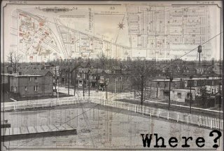
This image features an area map, 1899, and a photograph of Perth Avenue, 1916, with the familiar water tower in the distance.
As in those days, nobody really knows what to call our community. A number of different names have been used since Shedden Farms became a neighbourhood in 1887.
Some local residents have formed a group called Fuzzy Boundaries to initiate a naming process for the area. You are invited to attend a lively discussion about how we define our neighbourhood on Wednesday, May 13 at 7p.m. at the Perth Avenue Housing Cooperative (120 Perth). Local history buff Michael Monastyrskyj will show some old photos, and Urban Planner Beate Bowron will speak about neighbourhood identities. A Q&A will follow. All are welcome to attend this free event.
For details, visit www.fuzzyboundaries.ca or call Kevin at 416-537-1128.
Fuzzy Boundaries - meeting announcement postcard
April 24, 2009 - 1:08pm — vic
Front cover of the postcard sent out to the neighbourhood, inviting residents to attend the May 13 2009 "Fuzzy Boundaries" meeting.
Toronto Star Neighbourhood Map, v2.0
March 9, 2009 - 4:04pm — vic Toronto Star Neighbourhood Map, v2.0
On Sunday, The Toronto Star published an article about Toronto's neighbourhood names, and released an updated version of their online neighbourhood map.
One thing you may quickly notice on their map is that our neighbourhood is left out. We're still an unlabeled grey area sandwiched between The Junction and High Park on the west, Roncesvalles and Parkdale to the south, Wallace-Emerson and Brockton Village to the east, and Carleton Village to the north.
One other oddity is that The Star uses a Google map as a data source, and you can see in the underlying Google map that this neighbourhood is incorrectly labeled as "Silverthorn", which is actually a neighbourhood north of us in the Eglinton and Keele area.
The timing of this article and map is interesting, as there is already a group of local residents who are working on giving the neighbourhood a properly recognized and standardized name. Kevin Putnam was interviewed by the Toronto Star, and they started their article with the following: