![]()
Dupont
Boo Radley's Second Anniversary Party
June 3, 2009 - 7:52am — vicWe recently received this email from Mike and Shelley, owners of Boo Radley's at the corner of Dupont and Campbell. Their bar and grill has been in business for two years, and they are celebrating their anniversary this Friday.
Their pub is a great spot to drop in and have a drink in our neighbourhood, and the food really hits the spot too. Mike and Shelley have also expressed interest in getting more involved with our community, including offering up meeting space at Boo Radley's.
The Fixer: Dangerous conditions on Dupont St.
June 1, 2009 - 10:42am — vicJack Lakey, writer of the Toronto Star's "Fixer" column reported today on a dangerous pair of sewer grates on Dupont St., north side between Edwin Ave. and Osler Ave. (map).
"Pietro Taleporos emailed us photos of a sunken storm-sewer grate on the north side of Dupont, just west of Edwin Ave., with a utility cover next to it that caught the wheel of his 14-year-old son's bicycle and sent him sprawling."
Also, according to the article, "a small cone and a much larger, orange-and-black traffic pylon were placed over the rough patch", although this was definitely not the case when I rode by at about 8:40 this morning.
You can view the original article on The Star's website here.
This is definitely a dangerous situation for any cyclist who does not see this chewed up section of road in time to ride around it. Let's hope the City fixes this soon.
This section of Dupont St., between Dundas and Lansdowne, is also scheduled to have bicycle lanes installed, possibly sometime this summer. This will connect to the Annette St. bike lanes, and the West Toronto Rail Path. It will be even more critical to have this fixed before then, as the bicycle traffic will likely increase, while cyclists will be directed to ride right through the roughed-up curbside pavement.
A version of this article has been cross-posted to I Bike T.O.
Davenport Diamond Grade Separation, Open House #1
April 15, 2009 - 7:14am — vicWHAT: Public open house for GO Transit's Davenport Diamond grade separation project
WHEN: Wednesday April 22 2009, 5:30 to 8:30pm
WHERE: St. Josephat's School, 55 Pelham Ave. (map)
The following flyer is provided by GO Transit (Click through for a larger version):
PUBLIC OPEN HOUSE #1
Davenport Diamond Rail to Rail Grade Separation
City of TorontoTHE STUDY
GO Transit, the Province of Ontario's interregional public transit service for the Greater Toronto and Hamilton areas, is involved in an environmental assessment of the Davenport Diamond. The Study Area extends from Keele and Dufferin Streets to the West and East, and adjacent to Rogers Road and College Street in the North and South (as shown in the map).GO trains operating on the Newmarket corridor between Union Station and Barrie cross over the CP North Toronto corridor just south of Davenport Road. It is proposed that a grade separation of the Davenport Diamond will improve rail access along the two corridors.
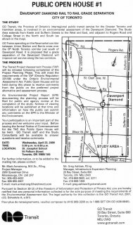
Davenport Diamond Grade Separation, Open House #1
April 15, 2009 - 7:03am — vic
A flyer for GO Transit's Davenport Diamond Rail to Rail Grade Separation project public meeting on Wednesday April 22, 2009.
Dupont/Royce and Olser, looking east (1914)
March 23, 2009 - 5:12pm — vic")
Note: The photo has a marking that says "Bloor St.", but the Toronto Archives says this is Dupont St. Comparing to other photos from the area, this does indeed appear to be Dupont St., and not Bloor.
Photo is from the City of Toronto Archives.
City of Toronto Archives Description Display
Archival citation Fonds 1231, Item 2064
Title Royce Avenue (Dupont Street) east to Osler Avenue
Date(s) of creation of record(s) March 9, 1914
Royce/Dupont and Dundas St., March 9 1914
March 23, 2009 - 5:03pm — vic
Royce Ave. (now Dupont St.) is one of the major roads that enters/exits out neighbourhood on both sides. Back in 1914, the intersection of Dundas St. West, Annette St., Royce Ave. (Dupont St.), and Old Weston Road was a much simpler affair, with a level crossing of the railway tracks. In this photo, we're looking east from Dundas St. over the tracks.
Photo is from the City of Toronto Archives.
City of Toronto Archives Description Display
Archival citation Fonds 1231, Item 2044
Royce/Dupont and Dundas St., April 6 1923
March 23, 2009 - 4:56pm — vic
Royce Ave. (now Dupont St.) is one of the major roads that enters/exits out neighbourhood on both sides. Back in 1923, the intersection of Dundas St. West, Annette St., Royce Ave. (Dupont St.), and Old Weston Road was a much simpler affair, with a level crossing of the railway tracks. In this photo, we're looking east from Dundas St. over the tracks.
Sometime after this photo was taken, an underpass was built to eliminate this level railway crossing at the edge of our neighbourhood.
Royce/Dupont and Dundas St., April 10 1914
March 23, 2009 - 4:49pm — vic
Royce Ave. (now Dupont St.) is one of the major roads that enters/exits out neighbourhood on both sides. Back in 1914, the intersection of Dundas St. West, Annette St., Royce Ave. (Dupont St.), and Old Weston Road was a much simpler affair, with a level crossing of the railway tracks. In this photo, we're looking east from Dundas St. over the tracks.
Here is another photo with a similar view from 1923.
Photo is from the City of Toronto Archives.
City of Toronto Archives Description Display
Looking north up the tracks from Dupont/Royce (1923)
March 23, 2009 - 4:38pm — vic")
April 6, 1923. Looking north up the CN/CP tracks from Royce Ave. (now Dupont St.). On the left is the old CPR West Toronto rain station at Dundas and Dupont, and Osler Ave. is off the screen to the right.
Here's another photo taken looking south from the same place on the same day.
Photo is from the City of Toronto Archives.
City of Toronto Archives Description Display
Archival citation Fonds 1231, Item 1096
Title Royce Avenue south
Date(s) of creation of record(s) April 6, 1923
Looking south down the tracks from Dupont/Royce (1923)
March 23, 2009 - 4:01pm — vic")
April 6, 1923. Looking south down the CN/CP tracks from Royce Ave. (now Dupont St.). On the right is Dundas St. West, and in the distance you can see the Wallace Ave. pedestrian bridge.
Here's another photo taken looking north from the same place on the same day.
Photo is from the City of Toronto Archives.
City of Toronto Archives Description Display
Archival citation Fonds 1231, Item 1093
Title Royce Avenue south CPR - C.N.R. Right-of-way east from Royce Avenue