TTC
Ana Bailão Comments on Transit City
December 22, 2010 - 7:39pm — Scott DThis is the response that Anna is sending out regarding Transit City. Not much specifics really and the odd thng abot tracking via postal codes.
Good Evening,
Thank you for taking the time to contact me on the future of Toronto's transit plans and for your patience in awaiting a reply. Our office has received an enormous amount of correspondence on this issue and a number of technical problems were encountered in attempting to respond.
The announcement by Mayor Ford to divert attention away from the Transit City project has been a source of much discussion.
Then and Now: Dundas and Sterling
March 14, 2010 - 9:52pm — vicAre you interested in old photos of our neighbourhood, and watching how this area has changed over time? Well, then keep an eye on this website, as I will be posting a collection of "Then and Now" photos. Most of the historical photos will be from the City of Toronto Archives, and current photos taken by current local photographers. Many of these were previously on display at the Perth-Dupont branch of the Toronto Public Library as part of the Fuzzy Boundaries project.
Do you have any old photos of this neighbourhood? Please feel free to get in touch if you're willing to share them!
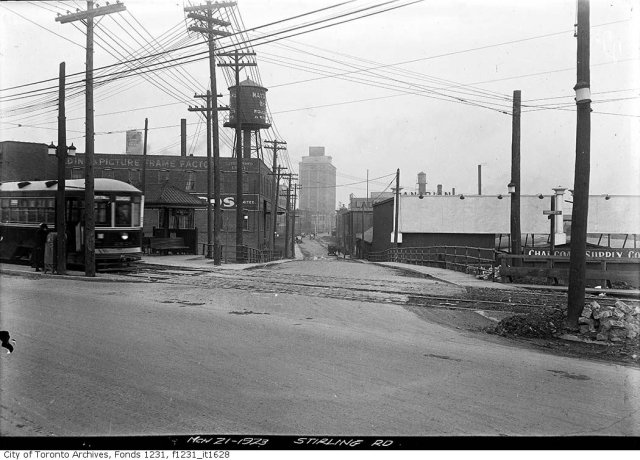
This comparison is from the southern tip of our neighbourhood at the intersection of Dundas St. and Sterling Rd. The old photo is from 1923, and the modern one was taken in 2009. The water tower is gone, streetcars are now in mixed traffic rather than in their own right-of-way on the north side of the street, and there are more trees. The Tower Automotive building still stands tall, although it is vacant inside. In the grand scheme of things, the view at this point hasn't changed too much!
THEN:
 March 21 1923: City of Toronto Archives, Fonds 1231, Item 1628
Dundas and Sterling, looking North (2009)
March 14, 2010 - 8:51pm — vic
Looking north from the intersection of Dundas St. West and Sterling Rd. This is a modern version of this photo from 1923.
Photo by Vic Gedris, 2009-10-18.
Dundas and Sterling, September 12 1936
June 22, 2009 - 3:12pm — vic
Archival citation Series 71, Item 11552
Title Dundas St, looking west, from north-east corner of intersection with Sterling Road; Photo taken 6 feet south of south rail, (Legal Department)
Author or Creator Alfred Pearson
Date(s) of creation of record(s) 1936
Physical description of record(s) 1 photoprint : b&w ; 13 x 18 cm
Form of material Photographs
Photographs - streetscapes
Forms part of Fonds 16; Toronto Transit Commission fonds
Series 71; Central photography series of the Toronto Transit Commission
Subjects Toronto (Ont. : 1834-1997)
TTC
Dundas and Sterling, September 12 1936
June 22, 2009 - 3:09pm — vic
Archival citation Series 71, Item 11550
Title Dundas St, looking west, to Sterling Road; photo taken 4 feet south of north curb, 113 feet east of hydro pole on north-east corner of Sterling Road and Dundas Street, (Legal Department)
Author or Creator Alfred Pearson
Date(s) of creation of record(s) 1936
Physical description of record(s) 1 photoprint : b&w ; 13 x 18 cm. — 1 photonegative : glass, b&w ; 13 x 18 cm
Form of material Photographs
Photographs - streetscapes
Forms part of Fonds 16; Toronto Transit Commission fonds
Dundas and Sterling, Dec 15 1931
June 22, 2009 - 2:48pm — vic
Archival citation Series 71, Item 9025
Title Looking west, on Dundas St, at Sterling Rd
Author or Creator Alfred Pearson
Date(s) of creation of record(s) December 15, 1931
Physical description of record(s) 1 photoprint : b&w ; 13 x 18 cm. - 1 photonegative : glass, b&w ; 13 x 18 cm
Forms part of Fonds 16; Toronto Transit Commission fonds
Series 71; Central photography series of the Toronto Transit Commission
Scope and content The item is a photograph of Dundas Street looking west at Sterling Road with waiting shelters.
Sterling Rd., north from Dundas St., March 21 1923
June 22, 2009 - 2:37pm — vic
Archival citation Fonds 1231, Item 1628
Title Sterling Road north from Dundas Street West
Date(s) of creation of record(s) March 21, 1923
Physical description of record(s) 1 photonegative : b&w ; 13 x 18 cm
Form of material Photographs
Photographs - streetscapes
Forms part of Fonds 1231; James Salmon collection
Subjects ROADS
Access conditions OPEN - No restrictions on these non-government records.
Dundas St., west towards Sterling Rd., March 21 1923
June 22, 2009 - 2:32pm — vic
Dundas St., looking west towards Sterling Rd. The rectangular water tower on the top-right is at Cowan's Cocoa on Sterling Rd.
Archival citation Fonds 1231, Item 1585
Title Dundas Street bridge west to Sterling Road
Date(s) of creation of record(s) March 21, 1923
Physical description of record(s) 1 photoprint : b&w ; 13 x 18 cm. — 1 photonegative : b&w ; 13 x 18 cm
Form of material Photographs
Forms part of Fonds 1231; James Salmon collection
Subjects BRIDGES
Access conditions OPEN - No restrictions on these non-government records.
Looking east at Dundas and Sterling, June 1 1937
June 22, 2009 - 2:27pm — vic
Archival citation Fonds 1231, Item 1567
Title Dundas Street east across Sterling Road
Date(s) of creation of record(s) June 1, 1937
Physical description of record(s) 1 photoprint : b&w ; 13 x 18 cm. — 1 photonegative : b&w ; 13 x 18 cm
Form of material Photographs
Photographs - streetscapes
Forms part of Fonds 1231; James Salmon collection
Subjects ROADS
Access conditions OPEN - No restrictions on these non-government records.
Community Meeting - Bloor Dundas 'Avenue' Study
January 13, 2009 - 1:43pm — vicThe following meeting announcement was sent to us from the City of Toronto's Planning Department, regarding the ongoing Bloor Dundas Avenue Study.
Community Meeting
Bloor Dundas ‘Avenue’ StudyMonday, January 26, 2009
6:30 p.m. - Open House
7:15 p.m. - PresentationHigh Park Baptist Church – Lower Auditorium
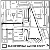
9 Hewitt Avenue (at Roncesvalles Avenue) (map)City staff and the City’s consultants have been working with the community to create a framework for new development and to identify needed service, transportation and streetscape improvements for the Bloor Dundas ‘Avenue’ Study area (see map).
In response to feedback at the November 18, 2008 community meeting, this meeting will provide additional information on land uses and related matters, and examples of built form scenarios for sites and sub-areas.
The meeting will start with an open house at 6:30 p.m. providing an opportunity to review display boards, ask questions and provide feedback. A presentation will follow at 7:15 p.m. To facilitate community feedback, material will be available on the Bloor Dundas ‘Avenue’ Study’s web page - www.toronto.ca/planning/bloordundas.htm - on Wednesday, January 21.
Please join us on Monday, January 26. Your input will help to improve and refine the draft
framework for the study area. The draft framework will result in a final study report, and subsequent new urban design and zoning by-law provisions for the Bloor Dundas ‘Avenue’ Study area.If you cannot attend the meeting, you can still make your views known by emailing ccambra@toronto.ca or by sending a fax to 416-397-4080 or by writing Corwin Cambray, Senior Planner, Policy and Research, 55 John Street, 23rd Floor, Toronto, Ontario, M5V 3C6.
You may also contact Councillor Gord Perks, Ward 14, Parkdale-High Park, at 416-392-7919 or by emailing councillor_perks@toronto.ca
