Industry
Tower Automotive: What's Inside?
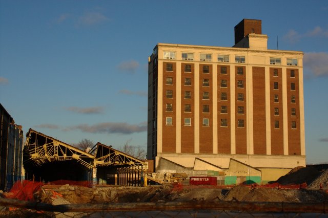
July 28, 2009 - 3:14pm — vic Tower Automotive, Sterling Rd.: As seen from the West Toronto Railpath. Photo by Vic Gedris, 2009-02-28.
Jonathan Castellino of BlogTO recently wrote an article / photo essay about the Tower Automotive site on Sterling Rd.
"Overlooking Toronto's junction[sic] rests the shell of Tower Automotive. Built in the first quarter of the 20th century, and closed in 2006, the former sheet-casting facility is currently being redeveloped into studio space. Thankfully, the tower itself--a 10-story building which no one in the neighbourhood can miss--as well as the facade of the low-lying former machining areas, will be preserved."
Although this building and surrounding grounds are fully secured right now, it has been a notable place for urban explorers to visit and photograph. It seems that Jonathan has visited many times, and has collected a great series of photos of the buildings' interiors, as well as the view from inside the tower.
I have always wondered what it looked like behind those walls, and what our neighbourhood, and the city beyond, looked like from the windows on the top floor. Perhaps someday I will be lucky enough to have a tour, but for now at least I can rely on some intrepid explorers' photos.
Sterling Rd., looking north, 1912-14
June 22, 2009 - 2:43pm — vic
Looking north on Sterling Rd., around 1912-1914.
Archival citation Fonds 1244, Item 7203
Title Sterling Road
Date(s) of creation of record(s) [ca. 1912]
Physical description of record(s) 1 photoprint : b&w
Form of material Photographs
Forms part of Fonds 1244; William James family fonds
Subjects Sterling Rd (Toronto, Ont.)
INDUSTRIAL FACILITIES
Access conditions OPEN - No restrictions on these non-government records.
Reseachers may not have access to original prints or negatives, but may use the reference prints available in the Research Hall.
Sterling Rd., north from Dundas St., March 21 1923
June 22, 2009 - 2:37pm — vic
Archival citation Fonds 1231, Item 1628
Title Sterling Road north from Dundas Street West
Date(s) of creation of record(s) March 21, 1923
Physical description of record(s) 1 photonegative : b&w ; 13 x 18 cm
Form of material Photographs
Photographs - streetscapes
Forms part of Fonds 1231; James Salmon collection
Subjects ROADS
Access conditions OPEN - No restrictions on these non-government records.
Dundas St., west towards Sterling Rd., March 21 1923
June 22, 2009 - 2:32pm — vic
Dundas St., looking west towards Sterling Rd. The rectangular water tower on the top-right is at Cowan's Cocoa on Sterling Rd.
Archival citation Fonds 1231, Item 1585
Title Dundas Street bridge west to Sterling Road
Date(s) of creation of record(s) March 21, 1923
Physical description of record(s) 1 photoprint : b&w ; 13 x 18 cm. — 1 photonegative : b&w ; 13 x 18 cm
Form of material Photographs
Forms part of Fonds 1231; James Salmon collection
Subjects BRIDGES
Access conditions OPEN - No restrictions on these non-government records.
13 Sterling Rd. (Standard Chemical) 1947
June 22, 2009 - 2:23pm — vic
Archival citation Subseries 3, Item 1416
Title 13 Sterling Road (Standard Chemical)
Date(s) of creation of record(s) [ca. 1947]
Physical description of record(s) 1 photonegative : b&w ; 13 x 18 cm
Form of material Photographs
Forms part of Fonds 200; Former City of Toronto fonds
Series 372; Dept. of Public Works photographs
Subseries 3; Assessment photographs
Access conditions OPEN - No restrictions on these government records.
Royce/Dupont and Dundas St., March 9 1914
March 23, 2009 - 5:03pm — vic
Royce Ave. (now Dupont St.) is one of the major roads that enters/exits out neighbourhood on both sides. Back in 1914, the intersection of Dundas St. West, Annette St., Royce Ave. (Dupont St.), and Old Weston Road was a much simpler affair, with a level crossing of the railway tracks. In this photo, we're looking east from Dundas St. over the tracks.
Photo is from the City of Toronto Archives.
City of Toronto Archives Description Display
Archival citation Fonds 1231, Item 2044
Bloor and Perth, looking west, 1923
March 23, 2009 - 3:31pm — vic
Photo is from the City of Toronto Archives.
City of Toronto Archives Description Display
Archival citation Fonds 1231, Item 1323
Title Bloor Street - Perth Avenue crossing from the east
Date(s) of creation of record(s) March 23, 1923
Physical description of record(s) 1 photoprint : b&w ; 13 x 18 cm. — 1 photonegative : b&w ; 13 x 18 cm
Form of material Photographs
Forms part of Fonds 1231; James Salmon collection
Subjects Bloor St W (Toronto, Ont.)
RAILWAYS
Bloor St. looking east towards Perth Ave., 1923
March 23, 2009 - 3:27pm — vic
Bloor St., looking east over the tracks towards Perth Ave. This is basically the same view as this photo from 1914. Not too long after, the Bloor St. railway underpasses were dug out.
Photo is from the City of Toronto Archives.
City of Toronto Archives Description Display
Archival citation Fonds 1231, Item 1322
Title Bloor Street - Perth Avenue crossing from the west
Date(s) of creation of record(s) March 23, 1923
NOW Magazine covers the Glidden Paint cleanup
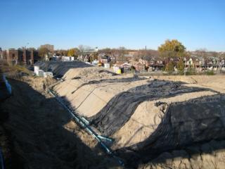
November 13, 2008 - 12:34pm — vic Wallace Ave. Brownfields: Looking north-east from the Wallace Ave. pedestrian bridge over the former Glidden Paint factory industrial lands. They are currently being cleaned up of industrial contaminants.
Today's edition of NOW magazine has a story about the Glidden Paint Factory cleanup on Wallace Ave next to the pedestrian bridge.
"For nine decades beginning in 1911, Glidden operated here, spilling untold amounts of solvents, chemicals with names too long to pronounce, with long-term health effects from exposure too scary to contemplate. The area, which forms part of the Junction Triangle, contains some of the most contaminated former industrial lands in the entire country."
You can read the entire article online at NOW Magazine's website.
If you would like more information about the cleanup efforts or to get involved with the Residents Association's Environment Committee, please contact us.
Wallace Ave. Brownfields
July 7, 2008 - 4:09pm — vic
Looking north-east from the Wallace Ave. pedestrian bridge over the former Glidden Paint factory industrial lands. They are currently being cleaned up of industrial contaminants.
Photo by Vic Gedris, 2007-11-18.