History
Then and Now: West Toronto Railpath
May 10, 2010 - 4:39pm — vicHere is the latest in the series of "Then and Now" photos. Do you have any old photos of this neighbourhood? Please feel free to get in touch if you're willing to share them!
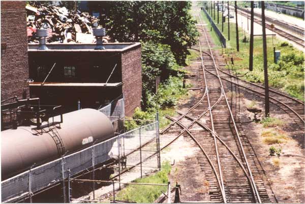
These photos compare the view south from the Wallace Ave. footbridge. The first photo was taken in July 1985, when the Old Bruce Service Track (formerly Toronto, Grey & Bruce railway) was still being used by local industries. The building on the left was the old Nacan Products (National Adhesives) factory, and on the top-right you can see GO Transit's Bloor Station platform. The tracks also serviced Solways scrap metals.
In the current view, taken on May 9 2010, the GO train station is still there, but the Old Bruce Service Track has been ripped up and replaced by the West Toronto Railpath. The Nacan factory has been converted into residential loft condos (Wallace Station Lofts), and there are no longer any railway tracks leading into Solways. However, if you walk down the Railpath past Solways, take a close look at the fence betwen Solways and the Brownstones on Bloor: You'll see remnants of that old track poking through the trees. Update: As of 2013, Solways and the track remnant are gone.
Speaking of trees: The massive tree of heaven next to the Wallace Ave. footbridge partially obscures this view now. I'm glad I took the "now" photo early enough in the spring before the leaves completely obscured it.
Much has changed in the last 15 years. For more history about the Toronto Grey & Bruce railway, please visit Old Time Trains (trainweb.org). Many thanks to Gord Billinghurst and Old Time Trains for the historical writeup, and allowing me to use this photo here.
THEN:
 Old Bruce Service Track, from Wallace Bridge: Photo by Gord Billinghurst, July 1985
Old Bruce Service Track, from Wallace Bridge, 1985
May 10, 2010 - 1:46pm — vic
Photo of the Old Bruce Service track, looking south from the Wallace Ave. pedestrian bridge, July 1985.
Photo by Gord Billinghurst, courtesy Old Time Trains (trainweb.org).
This track is now the home of the West Toronto Railpath, and the former Nacan (National Adhesives) factory on the left side is now a residential loft condo called Wallace Station Lofts. You can see an updated version of this photo from May 2010 here.
Then and Now: Wallace Ave.
March 30, 2010 - 11:59am — vicHere is the latest in the series of "Then and Now" photos. Do you have any old photos of this neighbourhood? Please feel free to get in touch if you're willing to share them!
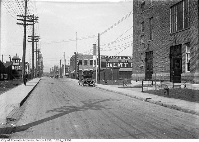
These photos compare the view looking westbound on Wallace Ave., over the CN/GO tracks between Campbell Ave. and Ward St. The first photo is from May 25 1923, and the second photo was taken on March 28 2009. The building on the north side of the street hasn't changed too much, but the south side was re-born as D&M Building Supplies at some point, but even that is now vacant and waiting to be developed. Even more recently (last week!), that building was demolished to make way for the "Junction Triangle Lofts".
It's also interesting to see the old railway watchtower on the south side of the street, and the "new" townhomes on Rankin Cres. The fire hydrant is still there too, but it has changed in style, and probably colour.
THEN:
 Wallace Ave., May 25 1923: City of Toronto Archives. Fonds 1231, Item 1301
Then and Now: Dundas and Sterling
March 14, 2010 - 9:52pm — vicAre you interested in old photos of our neighbourhood, and watching how this area has changed over time? Well, then keep an eye on this website, as I will be posting a collection of "Then and Now" photos. Most of the historical photos will be from the City of Toronto Archives, and current photos taken by current local photographers. Many of these were previously on display at the Perth-Dupont branch of the Toronto Public Library as part of the Fuzzy Boundaries project.
Do you have any old photos of this neighbourhood? Please feel free to get in touch if you're willing to share them!
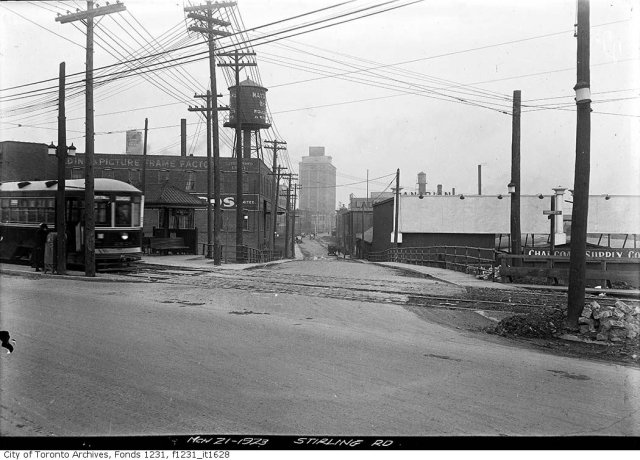
This comparison is from the southern tip of our neighbourhood at the intersection of Dundas St. and Sterling Rd. The old photo is from 1923, and the modern one was taken in 2009. The water tower is gone, streetcars are now in mixed traffic rather than in their own right-of-way on the north side of the street, and there are more trees. The Tower Automotive building still stands tall, although it is vacant inside. In the grand scheme of things, the view at this point hasn't changed too much!
THEN:
 March 21 1923: City of Toronto Archives, Fonds 1231, Item 1628
Then and Now: Dupont St. and Perth Ave.
February 23, 2010 - 5:22pm — vicAre you interested in old photos of our neighbourhood, and watching how this area has changed over time? Well, then keep an eye on this website, as I will be posting a collection of "Then and Now" photos. Most of the historical photos will be from the City of Toronto Archives, and current photos taken by me (Vic Gedris). Many of these were previously on display at the Perth-Dupont branch of the Toronto Public Library as part of the Fuzzy Boundaries project.
Do you have any old photos of this neighbourhood? Please feel free to get in touch if you're willing to share them!
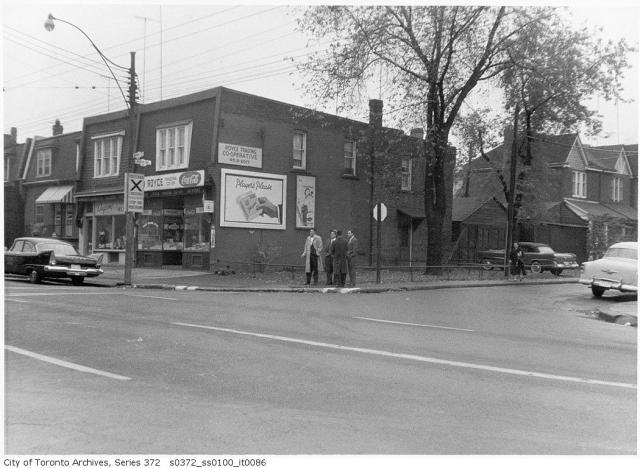
We'll start off this series comparing a photos of the north-west corner of Dupont St. and Perth Ave., taken on October 23 1958 with a modern version taken on March 28 2009.
THEN:
 Dupont and Perth, October 23 1958: City of Toronto Archives, Fonds 200, Series 372, Subseries 100, Item 86