Dundas
Dundas West - Bloor Mobility Hub Study
March 11, 2011 - 5:50pm — vicMeeting notice from Metrolinx:
PUBLIC OPEN HOUSE
DUNDAS WEST-BLOOR MOBILITY HUB STUDY
Metrolinx, an agency of the Province of Ontario, is helping transform the way the region moves by championing and delivering mobility solutions for the Greater Toronto and Hamilton Area (GTHA).
Background
The Big Move, Metrolinx’s Regional Transportation Plan for the GTHA, imagines a future in which key transit stations become mobility hubs. Mobility hubs consist of major transit stations and the surrounding area. They serve a critical function in the regional transportation system as the origin, destination, or transfer point for a significant portion of trips. They are places of connectivity where different modes of transportation – from walking to riding transit – come together seamlessly and where there is an intensive concentration of working, living, shopping and/or playing.
The Dundas West-Bloor Mobility Hub Study
We are conducting a study on the proposed Dundas West-Bloor Mobility Hub. The study includes the development of a plan to better integrate existing GO Transit and TTC services, as well as provide a design foundation for future major upgrades to GO Transit and TTC service, and a stop on the Union-Pearson Air Rail Link.
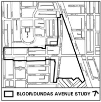
The study builds closely on the findings of the Bloor-Dundas Avenue Study prepared by Brook McIlroy and commissioned by the City of Toronto in 2009.
The Open House
You’re invited to attend our open house to find out more about this study.
Date: Wednesday, March 23, 2011
Time: 6:00 p.m. to 8:30 p.m.
Venue: Lithuanian House, 1573 Bloor Street West
Dupont St. and Railpath Closures, December 15 and 17-19 2010
December 8, 2010 - 3:54pm — vicThe following notice was sent out by Metrolinx to inform the community of upcoming road closures on Dupont St. between Osler and Dundas (under the tracks), and along the West Toronto Railpath above Dupont St. You can download the original PDF of this notice here.
GEORGETOWN SOUTH PROJECT
CONSTRUCTION UPDATE
The Georgetown South (GTS) Project will provide infrastructure improvements to meet existing GO Transit ridership demand and future growth. It will also accommodate the new Air Rail Link service between Union Station and Pearson International Airport.
Dupont Street Bridge
Road Closures: December 15 (Overnight) and 17-19
Project Description
The Dupont Street bridge currently has five tracks. As part of the GTS Project, a new bridge span will be installed between the existing GO tracks and the West Toronto Rail Path bridge to accommodate one additional track. The work will involve modifying the existing concrete abutments, constructing a new steel pier, and installing the new steel beam span.
Locally filmed video: Traveling Violations
September 23, 2010 - 4:48pm — vicCheck out this short video by Adeyemi Adegbesan and Colin Stanton, filmed locally in our neighbourhood, on Dundas St., the Wallace Ave. footbridge, and on the Railpath just below the bridge. "Traveling Violations" isn't about forgetting your passport or missing your train, but more about "traveling" in the basketball sense of the word. Check it out.
You can watch the video embedded above, or go directly to the Youtube page for it.
Wallace Bridge: Looking into the Junction Triangle
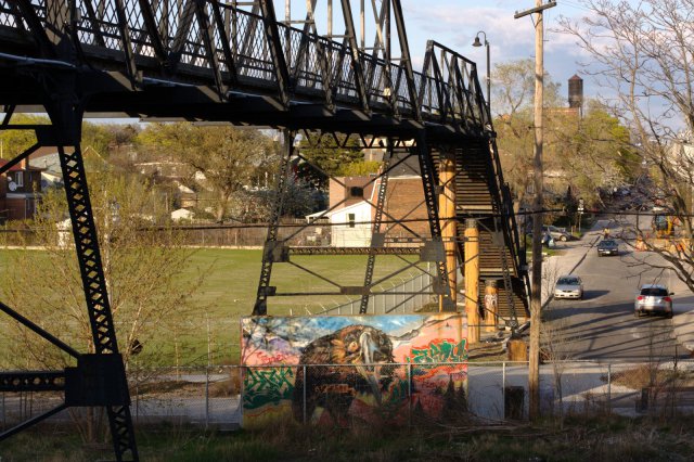
April 18, 2010 - 11:36pm — vic Wallace Ave. Bridge: Photo by Vic Gedris, 2010-04-16
They say "a picture is worth a thousand words".
I was walking home from the Dundas West subway station on Friday evening and decided to take this photo from the Dundas St. side of the Wallace Ave. pedestrian bridge. I always enjoy the view from here, especially since it contains two of our neighbourhood's most iconic sights: The bridge itself, and the old G.E. Water Tower near Lansdowne Ave.
When I came home and took a closer look at the photo, it struck me that there are many things going on within the frame of this picture. Little bits of history, neighbourhood icons, and changes that are happening rapidly. Here's what I spotted. Maybe there are some things I missed?
Then and Now: Dundas and Sterling
March 14, 2010 - 9:52pm — vicAre you interested in old photos of our neighbourhood, and watching how this area has changed over time? Well, then keep an eye on this website, as I will be posting a collection of "Then and Now" photos. Most of the historical photos will be from the City of Toronto Archives, and current photos taken by current local photographers. Many of these were previously on display at the Perth-Dupont branch of the Toronto Public Library as part of the Fuzzy Boundaries project.
Do you have any old photos of this neighbourhood? Please feel free to get in touch if you're willing to share them!
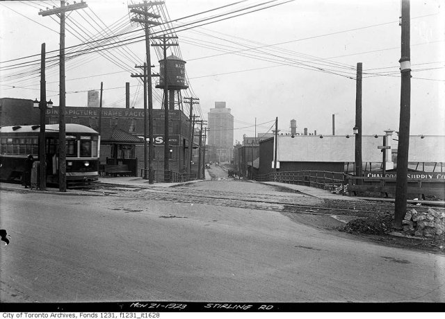
This comparison is from the southern tip of our neighbourhood at the intersection of Dundas St. and Sterling Rd. The old photo is from 1923, and the modern one was taken in 2009. The water tower is gone, streetcars are now in mixed traffic rather than in their own right-of-way on the north side of the street, and there are more trees. The Tower Automotive building still stands tall, although it is vacant inside. In the grand scheme of things, the view at this point hasn't changed too much!
THEN:
 March 21 1923: City of Toronto Archives, Fonds 1231, Item 1628
Dundas and Sterling, looking North (2009)
March 14, 2010 - 8:51pm — vic
Looking north from the intersection of Dundas St. West and Sterling Rd. This is a modern version of this photo from 1923.
Photo by Vic Gedris, 2009-10-18.
1540 Bloor West (Proposed Giraffe condo) at the OMB
January 18, 2010 - 4:16pm — vicThe following notice comes from the West Bend Community Association and Friends of Dundas and Bloor:
Make Your Views Known at the OMB Hearing for
1540 Bloor Street West (Giraffe)The OMB hearing for 1540 Bloor Street West (the Giraffe building) will be held January 19th – 21st, and Jan 25th - 29th, 2010, at the OMB office at 655 Bay Street, Suite 1600, beginning at 10:00 am. If possible we would like you to attend Tuesday to show a strong community presence.
Dundas St., north at Glenlake Rd. and Wallace Bridge, Oct. 23 1932
October 18, 2009 - 9:21am — vic
Archival citation Series 71, Item 9506
Title Dundas St West and Glenlake Ave, looking north-ward, case #4891, O.G. Miller, head-on collission with Carlton car, fatal
Author or Creator Alfred Pearson
Date(s) of creation of record(s) October 23, 1932
Physical description of record(s) 1 photoprint : b&w ; 13 x 18 cm. - 1 photonegative : glass, b&w ; 13 x 18 cm
Forms part of Fonds 16; Toronto Transit Commission fonds
Series 71; Central photography series of the Toronto Transit Commission
Dundas St., north at Glenlake Rd. and Wallace Bridge, Sept. 1957
October 18, 2009 - 9:17am — vic
Archival citation Subseries 100, Item 296
Title Dundas Street West, looking north from Glenlake
Date(s) of creation of record(s) [ca. September, 1957]
Physical description of record(s) 1 photoprint : b&w
Form of material Photographs
Forms part of Fonds 200; Former City of Toronto fonds
Series 372; Dept. of Public Works photographs
Subseries 100; General photographs
Access conditions OPEN - No restrictions on these government records.
Copyright conditions Copyright for these records is held by the City of Toronto...more
Bloor Dundas 'Avenue' Study - consultants' report and material posted
September 4, 2009 - 4:38pm — vic Bloor Dundas Avenue Study: Map from the City of Toronto.
The following email comes from Corwin Cambray, City of Toronto planner:
The Consultants' Final Report on the Bloor Dundas 'Avenue' Study and supporting material are now posted on the study's web site: www.toronto.ca/planning/bloordundas.htm
Feedback on the Final Report can be submitted by completing the Comments Form also posted or submitting comments directly to the City by September 18, 2009.